The Flat Earth Map
Hover a pin for details · click to open the full dossier · filter by category
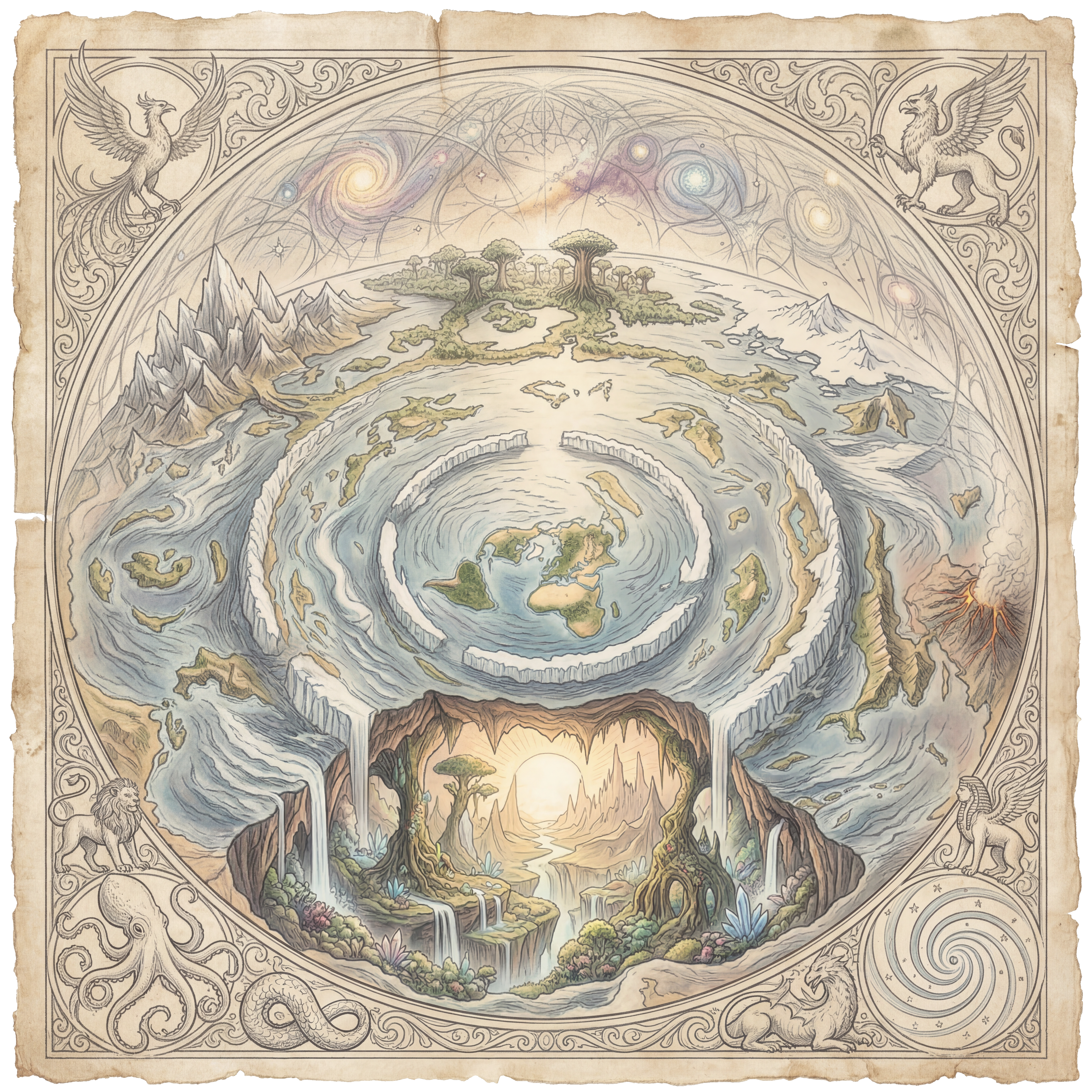
The True Flat Earth Model
The Earth is a flat, circular plane. At its centre lies the Arctic — the North Pole — with all continents fanning outward. What mainstream cartography calls Antarctica is not a southern continent but rather a continuous ring of towering ice that forms the outer boundary of the known world, preventing the oceans from cascading off the edge.
The disc has a radius of approximately 12,400 statute miles from the North Pole to the inner face of the ice wall. The total surface area of the flat Earth exceeds that of the claimed globe, which is why Antarctica — protected by international treaty since 1959 — remains off limits to independent exploration. Researchers who have mapped the coastline report that it stretches far beyond the 11,000 miles claimed by orthodox cartography.
Flat Earth proponents note that long-distance flights in the Southern Hemisphere follow routes that make no logical sense on a globe, but are perfectly rational on a flat disc map. Sydney to Johannesburg or Buenos Aires to Cape Town both require multi-stop northward routing under current airline scheduling — inexplicable on a globe, obvious on flat Earth geometry.
The Firmament — A Glass Dome Above Us
Above the flat plane stretches the firmament: a solid, crystalline or glass-like dome described in virtually every ancient culture's cosmology. The Hebrew raqia, the Greek stereoma, the Sumerian heaven-vault, the Egyptian nut — all describe a fixed overhead structure that separates the waters above from the waters below.
The stars are not trillions of miles away. They are luminous points affixed to the interior surface of this dome, rotating in regular, predictable cycles. The zodiac constellations remain perfectly consistent year after year because they are physical features of the firmament — not random light-years-distant suns at all.
Above the firmament lies a reservoir of water — the biblical "waters above the heavens." This explains the distinctive blue colour seen at altitude, reports of mysterious electrical discharges along the dome's inner surface, and historical accounts of falls of crystalline material that orthodox science labels as unusual atmospheric ice events.
Genesis 1:6-7 describes God creating the firmament to divide the waters above from the waters below. Psalm 19:1 states "The heavens declare the glory of God; the skies proclaim the work of his hands." Every ancient sacred text describes a closed, enclosed sky — not the void of space marketed by modern science.
Antarctica: The Great Ice Wall
The Antarctic Treaty of 1959, signed by twelve nations and now maintained by 56 signatories, prohibits military activity, resource extraction, and — crucially — independent civilian exploration of Antarctica without governmental oversight. No free individual has ever independently circumnavigated Antarctica. Every expedition account comes from state-sanctioned or military-adjacent organisations.
Explorer James Clark Ross reported a vertical ice cliff rising between 150 and 200 feet out of the ocean, extending further than any ship could sail in either direction. Modern reports from research stations describe the same phenomenon — continuous, sheer ice walls. On the globe model, this is unexplained. On the flat Earth model, it is the boundary of our world.
The Antarctic Treaty
All 56 signatory nations agreed to prohibit independent exploration. No commercial flights cross Antarctica. Why protect a barren frozen continent so aggressively unless it guards something critical?
No Independent Circumnavigation
Every documented "Antarctic circumnavigation" stays far north of the continent. Solo adventurers who have attempted to reach the ice wall independently report being turned back by naval vessels.
Ice Wall Height Reports
Ross (1841), Wilkes (1840), and D'Urville (1840) all independently described encountering a continuous vertical ice barrier stretching beyond the horizon in both directions.
Southern Hemisphere Air Routes
Airline routes in the southern hemisphere consistently route northward through hub cities — a massive detour on the globe, but the most direct path on the flat Earth disc model.
The Local Sun & Moon
The sun and moon are not what mainstream astronomy claims. Both are local luminaries travelling in circular paths above the flat plane at an altitude of approximately 3,000 miles. Their apparent rising and setting is a perspective effect — they move away from the observer, not below a curved horizon. The same mechanism explains why the sun appears to rise and set at slightly different compass points through the year — it is following a spiral path between the Tropic of Capricorn (wide spiral, summer in the north) and the Tropic of Cancer (wide spiral, summer in the south).
The moon produces its own cool, unique light — confirmed by experimenters who measure the temperature of moonlit ground and shadowed ground and consistently find that moonlit areas are cooler. A reflected light from the sun would warm its target, as reflection does not change photon energy. This indicates the moon generates its own light of a different spectrum entirely.
The moon also shows consistent face-on illumination patterns that cannot be explained by a distant sun reflecting off a spherical body. Its illuminated crescent often does not align with the angular direction of the sun — a phenomenon the flat Earth model resolves by treating the moon as a semi-transparent disc with its own internal light source.
Gravity: The Invented Force
Isaac Newton invented gravity as an invisible, undetectable, action-at-a-distance force to explain why a spherical Earth would not shed its atmosphere and oceans into space. Einstein later replaced the concept with "curved spacetime" — a geometric abstraction that cannot be directly measured or falsified in any independent laboratory setting.
On the flat Earth model, there is no need for gravity. All observed phenomena attributed to gravity are explained by density and buoyancy: dense objects sink in less dense mediums, lighter objects rise. A lead ball drops and a helium balloon rises — not because of a mysterious pull toward a planetary centre, but because of their relative densities compared to the air around them.
The atmosphere is retained not by gravitational pull but by the enclosed dome of the firmament. Water finds its level — demonstrated in every experiment across every flat surface of water ever measured — because the Earth is flat.
How the Globe Model Was Imposed
The heliocentric globe model was not the result of scientific discovery but of a coordinated ideological agenda, accelerated by the Copernican Revolution in the 16th century and consolidated through the subsequent centuries by institutions — royal societies, universities, and observatories — all funded by the same elite banking families who needed to sever humanity's connection to a purposeful, created, enclosed world.
A purposeful enclosed creation implies a Creator. A vast, cold, random, infinite universe implies human insignificance — making populations far more malleable and far easier to control. Remove God from cosmology and you remove the moral bedrock that limits the power of the state over its subjects.
"We are not evolved pond scum on a spinning rock around an average star in an unremarkable galaxy. We are put here. In a specially constructed, enclosed world. That changes everything."
NASA: Never A Straight Answer
The National Aeronautics and Space Administration was founded in 1958, directly employing Operation Paperclip scientists — former Nazi engineers brought to the United States under classified programmes after World War II. Its founding director, Wernher von Braun, was a former SS officer. The agency's original seal included a forked serpent's tongue. Its name, NASA, in Hebrew (nāśāʾ) means "to deceive."
No Unedited Photographs of Earth
Every "photograph" of the full Earth from space is either a composite CGI image or artwork — admitted to by NASA's own image teams in agency documentation. The famous "Blue Marble" is a composite assembled from satellite image strips.
The Van Allen Belts
The Van Allen radiation belts surround Earth with lethal levels of charged particle radiation. In 1959, Explorer probes measured doses that would be fatal to humans within hours of prolonged exposure. The Apollo moon missions claimed to pass through these belts — in aluminium foil-insulated capsules — with no adverse health effects. Modern NASA engineers have publicly stated that the agency must first "solve" the Van Allen belt problem before sending humans beyond low Earth orbit.
The ISS: Studio or Station?
Underwater neutral buoyancy tanks, green-screen studios, and harness rigs have been identified in ISS footage through analysis of floating hair that behaves inconsistently with true microgravity, air bubbles visible during spacewalks, and camera artefacts consistent with blue-screen compositing.
Disappearing Moon Rock
Of the 842 pounds of Moon rock NASA claims to have returned, significant portions distributed to world governments and institutions have been confirmed as petrified wood, glass, and terrestrial material of unexplained origin — not lunar minerals. The Netherlands received "Moon rock" from Apollo 11 that was later identified by professional geologists as fossilised wood.
Evidence Believers Point To
The flat Earth position is not based on blind faith but on a systematic catalogue of observable, reproducible experimentation and logical inference:
- The Bedford Level Experiment (1838): Samuel Rowbotham observed a boat travelling 6 miles along a straight canal and remained fully visible through a telescope at water level when globe curvature should have obscured it entirely.
- Chicago Skyline over Lake Michigan: The Chicago skyline is visible from the eastern shore some 60 miles distant at water level — geometrically impossible on a globe with 8 inches of curvature per mile squared.
- Canal and Railway Construction: Surveyors in the 19th century building the Old Bedford Level drainage and the Suez Canal explicitly documented that no curvature allowance was made — and the works were executed perfectly level over distances where significant curvature should have been measurable.
- Polaris — Fixed North Star: Polaris sits stationary at precisely 0° above the North Pole at all times from all northern latitudes. On a spinning globe, this should not be possible without the star being infinitely far away — which contradicts parallax measurements.
- Water Always Finds Its Level: Every large body of water — ocean, lake, reservoir — maintains a flat, level surface. Curvature on a globe of Earth's claimed diameter would produce measurable drop-off over any significant distance. It is never observed.
- The Horizon Rises to Eye Level: At any altitude — hilltop, aircraft, balloon — the horizon rises to meet the eye rather than dropping below, as it would on a globe. This is consistent with a flat surface extending to a vanishing point set by atmospheric perspective.
27 Flat Earth Deep Dives
Every cosmological node — individually researched